Monthly Archives: April 2011

Fire, cloud, rain 18 APR 11

It is not likely that rain will fall out of this cloud, but I can’t predict the weather.  I write and I photograph.

At about 2:00 p.m., CDT, I drove on the south side of Possum Kingdom Lake and photographed the ignition of fires on the west side of SH 16, north of US 180.  Please see my previous post for the photographs.  The smoke clouds began to rise and extend heavenward beyond what I could imagine.

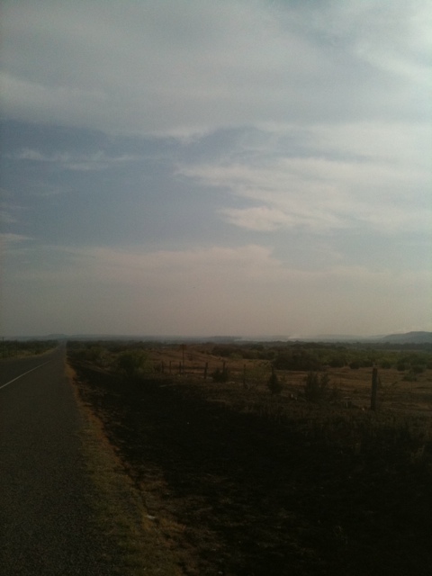
Thirty-minutes ago at 7:00 p.m., from my front pasture, maybe twenty-thirty miles away, I shot the following photograph of cumulus clouds that had arisen from the fire five hours ago over Possum Kingdom.   The photograph is not artsy, but documentary, and signifies a correlation of natural forces that are comprehensible, yet in the narrative of this terrible tragedy cannot be understood.

From the anguish and death of this Possum Kingdom fire, clouds form out of dust and ashes, rising so high they become cumulus.  On other days, they might of yielded rain to parched pastures in Texas and Oklahoma.  The connection between destruction and creation is just confusing right now, but it is how things are.

Out of fire, a cloud, perhaps rain.

This is the photograph without the telescopic lens. I am looking north from our place in north Erath County across the Nowack ranch where they have set up vehicles for evacuation if necessary.

Notes:

Corrections applied to third and fourth paragraphs, breaking up several compound sentences in original publication.  It’s an imperfect world and so are  fourth drafts.

4 Comments

Filed under Wildfire

100 degrees and fire at Possum Kingdom 18 APR 11

After transferring items between two trailers here on our place, I ate a ham sandwich and departed for the northern part of our region, up SH 108, FM 919 through Gordon and up to US 180, approximately twenty miles away.  I turned west on US 180 and drove to the Stephens County-Palo Pinto County, Texas line.  I had not driven farther two days ago than the SH 16 highway intersection.

The magnitude of this fire stuns me.  From Ioni Creek to the Stephens County line on US 180, about ten miles or so, the country is blackened and hot spots still smolder in the hills.  As I approached the intersection of US 180 and SH 16, I looked out the window of my F-150 and saw the beginning of a huge fire eruption at Possum Kingdom East.

Click the photographs with your mouse to enlarge and get detail.

Looking north from US 180 near intersection of SH 16, PK East Fire.

I drove farther from the SH 16- US 180 intersection — Highway Patrol blocked SH 16 north — and saw blackened countryside all the way to the Stephens County line.  I turned around and came back down US 180 and here is a shot of the smoke cloud.

Smoke cloud of PK East Fire on US 180 headed east back to SH 16 and Strawn.

I saw at least ten fires — not counting the hot spots — along US 180 and SH 16. Rio Vista, Joshua, Granbury and other volunteer units were scattered along the highway. With the outbreak of at least two fires northwest of Strawn, I saw the Cunningham Fire Department go into a ranch, led by the rancher and authorities.

Through-traffic in Strawn is prohibited and I cut across the country, using Davidson Cemetery Road to get back home.  Highway 16 in Strawn is scattered with vehicles and fire trucks.

I don’t like disaster-pandering posts.  I think they are bad form and take the mind away from applying its powers to correct defects that caused disasters in the first place.  Tours of Chernobyl are disgusting.   These events in my region — I am about fifteen-to-twenty miles south from the fires that have gone on for days it seems to me — are uncommon.  I’ve lived most of my life in Texas, in this region, and I’ve never seen fires like this.  My immediate surrounds in north Erath County are green and we’ve been fortunate.  Mingus, my mailing address, and Gordon, six-miles away, were ordered to evacuate several days ago.  As soon as these events are over, I will be glad to post on verbena and milkweed.

Tomorrow the Fire Weather Watch forecast is worse.  Today, it’s 100 deg. and wind at 20-25 m.p.h., humidity low.  If it gets worse, I won’t go to teach in Abilene, but stay here and monitor the place.

Burned structures at US 180 and SH 16.

12 Comments

Filed under Wildfire

Smokey Bear Hotshots of Ruidoso, New Mexico, help fight Possum Kingdom fires 18 APR 11

The Fire Weather Watch is on again for us today and tomorrow. The temperatures are to be in the 90s today with humidity levels dropping to single digits. The winds are forecast to be at 20-25 m.p.h. this afternoon. At last count, 1,200 firefighters are trying to retard the Palo Pinto-PK Fires and other spots in a ten-county area.

Here at our place, I am again prepared for evacuation although the fires are north of us some fifteen miles or so and the winds are prevailing from the south.  Our county and several counties south of us are in the Fire Weather Watch, however, so if a fire breaks out south of Flying Hat, we’ll have to be vigilant and take action.

* * *

The Smokey Bear Hotshots of Ruidoso, New Mexico, have sent their crew to the Palo Pinto-PK East Fires.

Brenda reported that she saw the trucks and equipment on Saturday on I-20 near Abilene, speeding to the complex of fires in our area.

News reports this morning state that the original fire was started by a campfire in the Possum Kingdom Lake vicinity.  Warnings had been posted against campfires.  Fire bans have been activated for several months in west-central Texas.

In addition to the tragic death of a firefighter near Gorman, Texas, ninety head of cattle died from this fire event in the last few days.  In most cases, ranchers cut their fences or drag them down to let the cattle drift and round them up later.  Too often, the fire spreads so fast that cutting fences is impossible.

On the last resort list of behaviors, I would cut fences and round-up later.

______________________________

Notes:

A hotshot crew consists of 20-22 members. There are two national formats certified for hotshot crews.

The first format is:

  • One GS-9 Superintendent;
  • Two GS-8 Foremans, (also known as Captains, or Assistant Superintendents)
  • Two GS-6/7 Squad Leaders;
  • Two – Four GS-5 Senior Firefighters; and
  • Approximately twelve GS-4 and/or GS-3 Temporary Firefighters.

The second format is

  • One GS-9 Superintendent;
  • One GS-8 Assistant Superintendents;
  • Three GS-6/7 Squad Leaders;
  • Three GS-5 Senior Firefighters; and
  • Approximately twelve GS-4 and/or GS-3 Temporary Firefighters.

In addition, crewmembers are assigned various other specialized roles within the crew structure. These specialties may include:

  • Medic – certified as First Responders, Wilderness First Responders, Emergency Medical Technician-level B or higher.
  • Helicopter Crewmember (HECM) – responsible for manifesting and packaging crew supplies and equipment into “sling-loads” for transport by helicopter long-line into and out of remote locations.
  • Faller – Highly skilled chainsaw operators that specialize in the safe falling of hazardous snags and burning or damaged trees.
  • Saw Team – Consisting of one Sawyer and one “Swamper”; The Sawyer will use a chain saw to cut brush and woody material away from the fires edge while the Swamper pulls and throws the cut material to the non-fire side of the fireline. These teams sometimes trade tasks with each tank of fuel used in the chain saw. The reason for this being that both cutting with the saw and swamping are both physically exhausting, but in different ways, therefore, trading tasks allows the team to do more work for longer. Also, operating the chainsaw is usually a more desirable task, compared to throwing brush and limbs, so trading tasks is more equitable.

(Wikipedia description)

6 Comments

Filed under Wildfire

Winds easing on FHR — Palo Pinto PK East Fire 17 APR 11

Flying Hat Ranch, 7:15 p.m. CDT, looking southward, wind is dying down.

Our back porch at Flying Hat Ranch, early evening after watching for fires today.

Here in Texas we have our disasters and I read today that Raleigh, North Carolina, has been hit hard by tornadoes.  These are events I do not like to have in common.

The winds are still high at 8:30 p.m., but are diminishing on our place in north Erath County, Texas (Flying Hat Ranch or FHR).  As you can see from the photos, we are fortunate that Spring has greened the pastures and trees about our porch and pastures.  North of us, only five miles or so, the country is not as green and in the Cross Timbers area north of Strawn, cedar trees and dry grass give fuel for fire.  I have neither heard nor read how these fires started, but arson is not suspected.  These events tumble out of random, discrete events, and we will probably never know how these fires began.

Here are photos taken this afternoon from the field.  All of these photos are north of Strawn, Texas, or at the command post.  Strawn is ten miles northwest of our place.

The order to evacuate Strawn is based on systematic criteria by the Texas Forest Service, Department of Public Safety and other state offices.  Strawn is not a ghost town as the result of the order, but villagers are quite cautious, standing in the yards and making their decisions to stay or leave.  I saw no panic or flight of citizens.  There were several dozens of horse trailers pulling horses going out of town along Davidson Cemetery Road.

With a click of your mouse, you may enlarge these photos.

North of Strawn on SH 16, six miles, looking west towards Ranger Hill area.

Bulldozers in field, cutting fire lanes along ranch pastures.

Cedar trees bursting in flame along SH 16.

Panoramic picture of fires west and northwest of Strawn.

Looking southward towards Strawn on SH 16.

North of Strawn, on Robinson Road. Fence posts burned from fire two days ago.

12 Comments

Filed under Wildfire

North of Strawn, Texas (Palo Pinto County, PK East Fire) 17 APR 11

Field report and photo by iPhone (kind of slow to thumb a post).

Smoke and hotspots.  Looking south on SH 16 in the direction of Strawn.

Palo Pinto County, PK East Fire – The entire city of Strawn (pop. 764) and portions of Palo Pinto County, described as areas west of Highway 16 and south of Possum Kingdom Lake, are being evacuated. An evacuation order has been given for the Peninsula on Possum Kingdom Lake. The Peninsula has approximately 300 homes and a campground. Fire is estimated at 1,000 acres.

20110417-055438.jpg

Leave a comment

Filed under Wildfire

Smoke clouds far northwest, west, 4:45 p.m. 17 APR 11

http://txforestservice.tamu.edu/main/article.aspx?id=12888

Texas Forest Service link is also on my front blog page.

The above link describes the current — Sunday, April 17, 2011 — fires in Palo Pinto, Stephens Counties of Texas.

I can see the large clouds of smoke from the Caddo, Strawn fires from our ranch house, north Erath County, CR 114 and SH 108.

I have friends south of Cisco.

5 Comments

Filed under Wildfire

Clear and windy! To the southeast 11:30 a.m., 17 APR 11

Location of Flying Hat Ranch is in north Erath County, Texas, CR 114, off of SH 108 about 0.2 mile.  It’s in the Cross Timbers country of Texas.

I am not usually given to posting frequently, but the wildfires in our area have prompted more writing.  I had 496 hits yesterday and an e-mail from KXAS NBC 5 in Dallas-Fort Worth requesting further “news” postings.  “News,” of course, to a television station is one thing, but to me, to us, in the blogosphere is another.  So here’s what’s going on poste haste, for my friends and acquaintances.  If it’s news to NBC 5, so much the better.

At 11:30 a.m., I took the following photo.  There’s no smoke, no fire.  The wind is 25 m.p.h. out of the south-southeast, the temperature is currently 80 degrees, and the humidity is 14 percent.  The gusts of wind are exceeding 30 m.p.h.  I have weather equipment, except for wind velocity, in the front yard.  The wind is quite frankly, scary.

I have repaired the Pecan Tree Pasture fence — more in a post later — from a deliberate cutting by thieves to get into our neighbor’s workshop.

Trailers are hitched, pasture gates are either unlocked or open for fire trucks and game wardens if necessary, Star is in the corral, the barn door is chained and water hoses are spread about the ranch house and barn.  Brenda and I have already gone through our checklist of what we will take out of the house, if necessary.  First and foremost, come Yeller and Lottie our dogs into the pickup, then our passports.  We load up Star, then throw what we can in the stock trailer.

Here’s the photo of the Texas landscape from the direction the wind is blowing.  It’s clear.  More later.

A click of your mouse will produce a larger, more detailed picture.  (Forget the copyright line, it just popped up.  Anyone can use this with proper attribution — as is the custom in our community.)

11:30 a.m. CDT, April 17, 2011, view from Poprock Hill, facing southeast, Flying Hat Ranch.

2 Comments

Filed under Wildfire

Red flag flying with good horse Star 17 APR 11

This Sunday is another day of remaining alert for smoke in west and central Texas.  Fire Weather Warnings have been issued.  Red flags are flying.

Before we focus at noon until late evening on possible wildfires, errands are run and Star, our paint gelding is fed.

Star is out of isolation for rabies since Friday.  Now, after two weeks of isolation, he can once again nuzzle his horse neighbors next door and set his huge neck upon my shoulder.  Here is a photo of Star taken last week.

Star Bars Moore APHA 808164, loafing in arena pasture under mesquites.

So that is some of the good news here on Flying Hat Ranch or “Ranchito” as Donald Worcester, a deceased friend of mine, used to call his 142 acres near Fort Worth.

Unfortunately, later today we have to work with the following forecast from the National Weather Service:

URGENT – FIRE WEATHER MESSAGE…UPDATED NATIONAL WEATHER SERVICE FORT WORTH TX 436 AM CDT SUN APR 17 2011 TXZ091-092-100gt;103-115gt;119-129gt;134-141gt;147-156gt;162-174-175-171800- /O.CON.KFWD.FW.W.0014.110417T1700Z-110418T0100Z/ MONTAGUE-COOKE-YOUNG-JACK-WISE-DENTON-STEPHENS-PALO PINTO-PARKER- TARRANT-DALLAS-EASTLAND-ERATH-HOOD-SOMERVELL-JOHNSON-ELLIS- COMANCHE-MILLS-HAMILTON-BOSQUE-HILL-NAVARRO-FREESTONE-LAMPASAS- CORYELL-BELL-MCLENNAN-FALLS-LIMESTONE-LEON-MILAM-ROBERTSON- 436 AM CDT SUN APR 17 2011 …RED FLAG WARNING REMAINS IN EFFECT FROM NOON TODAY TO 8 PM CDT THIS EVENING… A LOW PRESSURE SYSTEM IS EXPECTED TO DEEPEN ACROSS THE TEXAS AND OKLAHOMA PANHANDLES LATER TODAY RESULTING IN GUSTY SOUTHERLY WINDS. SOUTHERLY WINDS 15 TO 25 MPH WITH GUSTS TO 35 MPH CAN BE EXPECTED ALONG WITH HUMIDITY VALUES AROUND 20 PERCENT. THE COMBINATION OF GUSTY WINDS…LOW HUMIDITY…AND DRY FUELS WILL LEAD TO DANGEROUS FIRE WEATHER CONDITIONS THROUGH EARLY EVENING. PRECAUTIONARY/PREPAREDNESS ACTIONS… A RED FLAG WARNING MEANS THAT EXTREME FIRE WEATHER CONDITIONS ARE EITHER OCCURRING NOW…OR WILL SHORTLY. A COMBINATION OF STRONG WINDS…LOW RELATIVE HUMIDITY…AND DRY VEGETATION WILL CREATE EXPLOSIVE FIRE GROWTH POTENTIAL. AVOID ALL OUTSIDE BURNING AND WELDING TODAY. DO NOT TOSS LIT CIGARETTE BUTTS OUTSIDE. REPORT WILD FIRES TO THE NEAREST FIRE DEPARTMENT OR LAW ENFORCEMENT OFFICE.
I obtain this weather warning when I click on our weather service and a red banner streaks alarmingly across the top of the page.  Catches your attention real fast!  There’s a red flag flying today with our good horse, Star.  All will be well and if not, we’ll manage with help of a Star.

6 Comments

Filed under Flying Hat Ranch, Star, Wildfire

Hot spots and Possum Kingdom Lake wildfire 16 APR 11

US Highway 180, south of Possum Kingdom Lake

I went out this morning to view and photograph the Possum Kingdom Lake wildfire event. I was not able to see Possum Kingdom Lake because I do not have press credentials and State Highway 16 was blocked at the intersection of US 180.

Today the winds are calm, but tomorrow afternoon a Red Flag warning has been issued for west-central Texas.  I drove the F-250 from our ranch north of I-20 on SH 919 to Gordon, cut west along the Schoolhouse Road north of Gordon to St. Boniface Catholic Church on Dodson Prairie.  The elk behind the high field fence on the Guest Ranch appeared unharmed.  After driving by St. Boniface, I turned north on SH 16 and journeyed to US 180, turning west and headed in the direction of Possum Kingdom and Breckenridge, Texas.

As I ascended the small mountains about Ioni Creek on US 180, I saw blackened trees and fence posts that had burned last night.  The pasture lands were turned to cinders, but I saw no livestock affected.  Hotspots of fence posts and erosion barriers emitted smoke and flames.  Towards Possum Kingdom Lake, the Highway Patrol blockaded SH 16, and after a few more miles going west on US 180, I turned around and started back to the ranch.

I turned south on SH 16 towards Strawn, past Schoolhouse Road and St. Boniface and then realized why the Texas Forest Service and state officials had ordered an evacuation of Mingus and Gordon last night.  The fire last evening had leapt the highway and was headed southwest towards the two villages.  The Forest Service, Brazos Volunteer Fire Department and the Lone Camp Volunteers (other volunteer departments were also involved) had stopped it last night, but the frontline of combating it today and tomorrow was east of SH 16, about six miles north of Strawn.  The Texas Department of Public Safety and Forest Service set up command posts in Strawn.

The winds tomorrow are forecast out of the south at 25 m.p.h. so the winds will carry any fire to the north and east.  The Possum Kingdom Lake fire will not affect us.  We will wait and see what else transpires when the dry line (nicknamed the Marfa Line) passes by tomorrow afternoon, lowering the humidity.  Our ranch lies south of I-20 and we will be prepared for any outbreak of fire in our area.  That means that we have trailers hitched, grass and lawns watered and the dogs ready to go with Star, our paint gelding.

With the exception of the sunset photograph, I have the photographs arranged in the order I traveled and time that I shot the pictures.  When I came back to the house, I had to take off my coat and leave it in the utility room because it stank of smoke.

This slideshow requires JavaScript.

Notes:

Correction:  the church is St. Boniface, not St. Alban.

Changed verb conjugation: leap, leaped, leapt.

All photographs were taken NEF, uploaded JPEG.  NEF file sizes ca. 10 megs., a digital negative.

17 Comments

Filed under Wildfire

Mingus and Gordon, Texas, evacuated 15 APR 11

Officials have ordered the evacuation of Mingus and Gordon, Texas, six miles to the north of us.

News link on evacuation.

10:51 p.m.  I have returned from Gordon and Mingus.  Fire trucks are concentrating at Gordon.  It’s fairly pacific there.  Russell Stowe Ford Company seems to be moving all of their vehicles out of the building to another location.  Some people are huddled at the volunteer fire department building.

The game warden said that our ranchito — south of Gordon six miles — would probably be okay and not to worry.  He did state that the situation was serious or they wouldn’t have issued the evacuation order.  Obviously, I thought to myself.  Not much help there.

I went to Mingus and the bars were open and still serving drinks and the lights are on.  A Burlington-Santa Fe freight train came roaring through town as I circled the Mule Lip Bar, so at least the railway tracks are presently clear between Mingus and Abilene.  I much prefer Mingus to Gordon.

I came back to our ranch on the south access road of Interstate 20 and I saw in the distance the glow of the fire north of Mingus-Gordon.  I estimate it was at least fifteen to twenty miles away, maybe more.

The wind has died down, probably around ten m.p.h.   I can look directly up in the sky and see the moon despite the smoke.

14 Comments

Filed under Wildfire